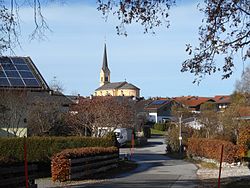
Chieming
Chieming | |
|---|---|
 Chieming am Chiemsee | |
Location of Chieming within Traunstein district  | |
| Coordinates: 47°54′N 12°32′E / 47.900°N 12.533°E | |
| Country | Germany |
| State | Bavaria |
| Admin. region | Oberbayern |
| District | Traunstein |
| Government | |
| • Mayor (2020–26) | Stefan Reichelt[1] (CSU) |
| Area | |
| • Total | 37.74 km2 (14.57 sq mi) |
| Elevation | 537 m (1,762 ft) |
| Population (2022-12-31)[2] | |
| • Total | 5,074 |
| • Density | 130/km2 (350/sq mi) |
| Time zone | UTC+01:00 (CET) |
| • Summer (DST) | UTC+02:00 (CEST) |
| Postal codes | 83339 |
| Dialling codes | 08664 |
| Vehicle registration | TS |
| Website | www.chieming.de |
Chieming (German pronunciation: [ˈkiːmɪŋ]) is a municipality in the district of Traunstein in Bavaria, Germany.
Climate[edit]
| Climate data for Chieming (1991–2020 normals) | |||||||||||||
|---|---|---|---|---|---|---|---|---|---|---|---|---|---|
| Month | Jan | Feb | Mar | Apr | May | Jun | Jul | Aug | Sep | Oct | Nov | Dec | Year |
| Mean daily maximum °C (°F) | 3.3 (37.9) |
5.1 (41.2) |
9.6 (49.3) |
15.0 (59.0) |
18.5 (65.3) |
22.5 (72.5) |
24.1 (75.4) |
23.5 (74.3) |
18.9 (66.0) |
14.5 (58.1) |
8.3 (46.9) |
4.7 (40.5) |
14.0 (57.2) |
| Daily mean °C (°F) | −0.2 (31.6) |
0.6 (33.1) |
4.5 (40.1) |
9.4 (48.9) |
13.1 (55.6) |
17.2 (63.0) |
18.6 (65.5) |
18.0 (64.4) |
13.7 (56.7) |
9.7 (49.5) |
4.5 (40.1) |
1.0 (33.8) |
9.5 (49.1) |
| Mean daily minimum °C (°F) | −3.4 (25.9) |
−2.7 (27.1) |
0.4 (32.7) |
3.8 (38.8) |
7.9 (46.2) |
12.0 (53.6) |
13.2 (55.8) |
12.8 (55.0) |
9.2 (48.6) |
5.4 (41.7) |
1.0 (33.8) |
−2.1 (28.2) |
4.9 (40.8) |
| Mean monthly sunshine hours | 70.9 | 95.9 | 143.7 | 202.3 | 195.9 | 224.7 | 241.1 | 230.1 | 172.9 | 130.9 | 80.1 | 72.4 | 1,843.1 |
| Source: NOAA[3] | |||||||||||||
Etymology[edit]
The name Chieming, Chiemsee and the name of the area Chiemgau go back to the Old High German personal name Chiemo (7th/8th century). At the end of the 8th century the name Chiemgau appeared for the first time in documents as Chimigaoe but it stood at that time for a smaller area around the village of Chieming.[citation needed]
Education[edit]
In Chieming there are
- 3 kindergartens
- a primary- and middle school,
- the Gymnasium Landschulheim Schloss Ising
References[edit]
Wikivoyage has a travel guide for Chieming.
- ^ Liste der ersten Bürgermeister/Oberbürgermeister in kreisangehörigen Gemeinden, Bayerisches Landesamt für Statistik, 15 July 2021.
- ^ Genesis Online-Datenbank des Bayerischen Landesamtes für Statistik Tabelle 12411-003r Fortschreibung des Bevölkerungsstandes: Gemeinden, Stichtag (Einwohnerzahlen auf Grundlage des Zensus 2011) (Hilfe dazu).
- ^ "Chieming Climate Normals 1991–2020". National Oceanic and Atmospheric Administration. Archived from the original on 16 September 2023. Retrieved 16 September 2023.


