Bemowo
Bemowo | |
|---|---|
 The Bemowo District Hall | |
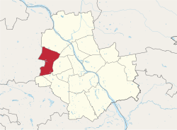
 Location of Bemowo within Warsaw | |
| Coordinates: 52°14′19″N 20°54′48″E / 52.23861°N 20.91333°E | |
| Country | |
| Voivodeship | Masovian |
| County/City | Warsaw |
| Government | |
| • Mayor | Urszula Kierzkowska |
| Area | |
| • Total | 24.95 km2 (9.63 sq mi) |
| Population (2019) | |
| • Total | 123,932[1] |
| Time zone | UTC+1 (CET) |
| • Summer (DST) | UTC+2 (CEST) |
| Area code | +48 22 |
| Website | bemowo.waw.pl |
Bemowo is a district of Warsaw located in the western part of the city. Its territory covers the western belt of the former district of Wola, which was incorporated to Warsaw in the year 1951. The name of the district derives from the surname of General Józef Bem.
Neighbourhoods within the district[edit]
- Lotnisko
- Fort Radiowo
- Boernerowo
- Bemowo Lotnisko
- Fort Bema
- Groty
- Górce
- Chrzanów
- Jelonki Północne
- Jelonki Południowe
Twin towns – Sister cities[edit]
Bemowo is twinned with:
 Óbuda-Békásmegyer (Budapest), Hungary[2]
References[edit]
- ^ "Powierzchnia i ludność w przekroju terytorialnym w 2019 roku. Tabl. 21 Powierzchnia, ludność oraz lokaty według gmi". stat.gov.pl. Główny Urząd Statystyczny. Retrieved 2 September 2020.
- ^ "Testvérvárosok" (in Hungarian). Óbuda-Békásmegyer. Retrieved 2023-01-14.
External links[edit]
- The official website of Bemowo Archived 2021-05-10 at the Wayback Machine
- A local info-website
- A local Internet newspaper for Bemowo
- Bemowo Pictures - Amateur movie group from Bemowo Archived 2008-03-27 at the Wayback Machine
Wikimedia Commons has media related to Bemowo.

