Karula National Park
| Kalia Rout | |
|---|---|
 Karula National Park | |
| Location | Estonia |
| Coordinates | 57°42′52″N 26°29′12″E / 57.71444°N 26.48667°E |
| Area | 123.64 km2 (47.74 sq mi) |
| Established | 1979 |
| Website | www |
Karula National Park is a national park in southern Estonia. It was established in 1979 as a protected area and in 1993 became a national park. It is the smallest national park in Estonia.[1]
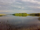
The park is located in Antsla and Rõuge parishes in Võru County and Valga Parish in Valga County. The park covers almost a third of the Karula Uplands and is characterised by its hilly topography, many lakes, great biodiversity, and traditional cultural landscape. The flora of the national park is rich, and includes several species red-listed in Estonia, such as the Baltic orchid, mezereon, and the daisyleaf grape fern; the last is only found in three locations in Estonia, and Karula is one of them. The fauna also includes unusual and threatened species, such as the pond bat, lesser spotted eagle, and black stork. Mammals such as elk, lynx, and polecats are common.[2]
See also[edit]
References[edit]
- ^ Karula National Park in Estonia Protected Planet
- ^ "Karula National Park". Retrieved 4 February 2013.
External links[edit]
 Media related to Karula National Park at Wikimedia Commons
 Karula National Park travel guide from Wikivoyage
- Karula National Park


