Webcams nearby
Oʻahu - Haleʻiwa - Waialua Bay

Webcams nearby


Advertisements
Description
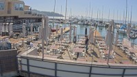
View from Haleʻiwa Beach House restaurant to the fishing port and Waialua Bay. The thumbnail is a preview. The current webcam view is available on the external website.
Time
2026-01-17 04:24 HST
Provider website
Refresh
Live stream
Advertisements
Weather station

Temperature: 19 °C (65 °F)
Precipitation: 0.0 mm
Cloud cover: 0%
Wind speed: 18 km/h (11 mph)
Precipitation: 0.0 mm
Cloud cover: 0%
Wind speed: 18 km/h (11 mph)
Wind direction: 58 °
Pressure: 1016 hPa
Humidity: 66%
Visibility: 16 km
Pressure: 1016 hPa
Humidity: 66%
Visibility: 16 km
Sunrise: 07:13 am
Sunset: 06:12 pm
Sunset: 06:12 pm
Moonrise: 05:46 am
Moonset: 04:31 pm
Moonset: 04:31 pm
Max temperature: 21 °C (70 °F)
Min temperature: 17 °C (63 °F)
Ultraviolet index: 2
Min temperature: 17 °C (63 °F)
Ultraviolet index: 2

Temperature: 21 °C (70 °F)
Precipitation: 0.1 mm
Cloud cover: 47%
Wind speed: 23 km/h (14 mph)
Precipitation: 0.1 mm
Cloud cover: 47%
Wind speed: 23 km/h (14 mph)
Wind direction: 54 °
Pressure: 1015 hPa
Humidity: 61%
Visibility: 10 km
Pressure: 1015 hPa
Humidity: 61%
Visibility: 10 km
Sunrise: 07:13 am
Sunset: 06:12 pm
Sunset: 06:12 pm
Moonrise: 05:46 am
Moonset: 04:31 pm
Moonset: 04:31 pm
Max temperature: 21 °C (70 °F)
Min temperature: 17 °C (63 °F)
Ultraviolet index: 2
Min temperature: 17 °C (63 °F)
Ultraviolet index: 2

Temperature: 21 °C (71 °F)
Precipitation: 0.2 mm
Cloud cover: 58%
Wind speed: 27 km/h (17 mph)
Precipitation: 0.2 mm
Cloud cover: 58%
Wind speed: 27 km/h (17 mph)
Wind direction: 68 °
Pressure: 1016 hPa
Humidity: 62%
Visibility: 10 km
Pressure: 1016 hPa
Humidity: 62%
Visibility: 10 km
Sunrise: 07:13 am
Sunset: 06:12 pm
Sunset: 06:12 pm
Moonrise: 06:36 am
Moonset: 05:28 pm
Moonset: 05:28 pm
Max temperature: 21 °C (71 °F)
Min temperature: 18 °C (64 °F)
Ultraviolet index: 1
Min temperature: 18 °C (64 °F)
Ultraviolet index: 1
Temperature: 22 °C (72 °F)
Precipitation: 0.6 mm
Cloud cover: 78%
Wind speed: 27 km/h (17 mph)
Precipitation: 0.6 mm
Cloud cover: 78%
Wind speed: 27 km/h (17 mph)
Wind direction: 95 °
Pressure: 1015 hPa
Humidity: 65%
Visibility: 10 km
Pressure: 1015 hPa
Humidity: 65%
Visibility: 10 km
Sunrise: 07:13 am
Sunset: 06:13 pm
Sunset: 06:13 pm
Moonrise: 07:22 am
Moonset: 06:25 pm
Moonset: 06:25 pm
Max temperature: 22 °C (72 °F)
Min temperature: 19 °C (66 °F)
Ultraviolet index: 1
Min temperature: 19 °C (66 °F)
Ultraviolet index: 1
Location map
Comments